SR 520 Montlake Lid and Bridges

SR 520 Montlake Lid and Bridges
Seismic Resiliency Upgrades Reconnect a Neighborhood and Add New Mobility Options
- 3-acre landscaped lid with transit center and direct access ramps over a busy highway
- 73-foot-wide pedestrian and bike bridge
- New highway bridge and additional transit and carpool lanes
- New direct HOV access ramps from SR 520 to the lid
- Multiple services from preliminary design through construction management
The SR 520 Corridor had multiple structures that were seismically vulnerable. The need to replace these structures created an opportunity to improve this vital east-west corridor and reconnect the Montlake neighborhood which was divided by the original highway construction. The project also improves mobility for all users including transit, HOV, bicycles and pedestrians.
Improvements to the highway and its passage over Union Bay will provide safer and more reliable travel. The project is part of WSDOT’s larger SR 520 Bridge Replacement and HOV Program that is making significant improvements to SR 520 corridor in Seattle. HDR has been a key part of the $6.2 billion program since 2005 as its general engineering consultant.
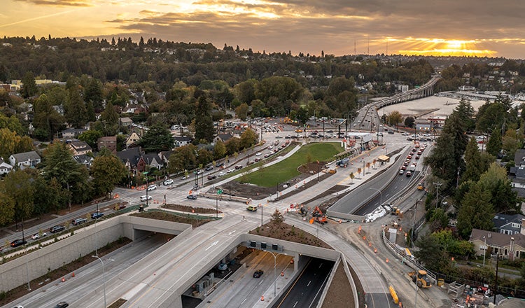
On the Montlake section, the project also reconnects the community through a new 3-acre landscaped lid over the highway. We filled several roles for the Montlake project part of the program. Our team provided preliminary design and environmental services, prepared construction documents and performed design reviews and construction management. We were involved from the beginning of the project and its conceptual designs, crafting a design that meets the needs of multiple high-profile stakeholders, including adjoining historic neighborhoods, the University of Washington, the Arboretum Foundation, a nearby yacht club and a NOAA research facility.
New Highway Lid
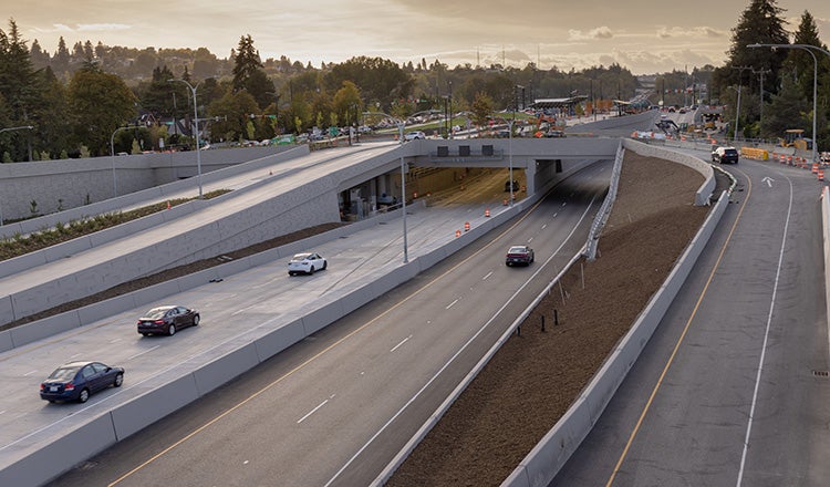
One of the most noticeable features of the project is the new highway lid that stretches across SR 520. The 3-acre lid includes new green space for pedestrians and a transit center that will improve regional mobility. We led the development of the project for WSDOT including alternatives analysis, defining lid programing, engineering validation, and stakeholder coordination including Seattle Design Commission endorsement. The project also required extensive coordination with the City of Seattle Department of Transportation, Seattle Public Utilities, Seattle City Light and the Seattle Parks Department.
One of the major challenges for the Montlake project was reaching community consensus. The final concept for the lid was refined through a community engagement process that led to significant design changes. These included a separate bicycle and pedestrian bridge and the addition of more usable open space on top of the lid.

Our team assisted WSDOT in navigating the redesign of a single 1,400-foot lid into a smaller lid design to reduce mechanical ventilation costs. The finished project comprises a roughly 700-foot lid with a partner 73-foot wide bicycle and pedestrian land bridge. The project, delivered via design-build, implements visions HDR has created for landscape character, transit hub features and non-motorized connections. The lid also serves as a gateway to nearly 300 acres of adjacent parklands and the University of Washington.
Many other challenges also had to be addressed on the complex project. Construction of the lid included replacing a 54-inch water main owned by Seattle Public Utilities. A 96-inch masonry sewer line that crosses under the highway had to be protected in place. On the lid itself, extensive use was made of geofoam under the landscaped areas to reduce overall loading on the lid structure. During construction, noise and vibration were carefully monitored and controlled to limit impact to the research at the NOAA facility and minimize damage to homes in the historic neighborhood.
Smart Design Choices
Designing a project is one thing. Building it while maintaining traffic is another. HDR provided a staging and traffic management plan for the project. Construction staging had to be carefully thought through to maintain two lanes of traffic in each direction on SR 520 with limited closures. Additionally, Montlake Boulevard – one of the three busiest arterials in the city — had to be remain open with limited closures throughout the project. The bridge carrying Montlake over SR 520 was demolished and the street is now incorporated into the new highway lid. Provisions were made for safe pedestrian and bicycle travel through the corridor during construction.
The staging and traffic management plans prepared by HDR and included in the design-build request for proposal were largely followed by the design-build team. The staging has worked as planned and impacts to the public have been minimal. The planning work done by HDR determined how many night and weekend closures would be allowed during the four years of construction, and the contractor has been able to complete the work within the closures allowed in the contract.

The project includes a number of major elements beyond the lid. A new approach bridge carries SR 520 eastbound to connect the Montlake neighborhood to the highway’s floating bridge. This new bridge is seismically stronger and was designed to match the westbound bridge, replaced as part of a separate project. Design choices on the bridge helped create stronger foundations that includes seismic base isolation, reducing the number of piers in the water and allowing for utilization of longer prestressed girders.
Mobility and reliability are greatly improved with the addition of new transit and carpool lanes across Lake Washington and at the Montlake Boulevard interchange. Wider highway shoulders provide more room during emergencies to avoid traffic backups.
The project also includes a new pedestrian and bike bridge just east of the lid. This 73-foot wide bridge offers a safe and attractive option for users moving from one side of the busy highway to the other. The bridge, featuring extensive greenery and an overlook facing the bay, provides a connection between the SR 520 regional trail and nearby arboretum trail as well as improved access to local neighborhoods.


